A UK renewables developer needed to understand the terrain across a 100-hectare parcel of farmland before finalising the layout for a new solar array. Ground le...
Many UK sites don't give up their ground level easily. Dense vegetation, long linear corridors and hard-to-reach terrain can defeat a camera-only survey before...
Quoting a commercial rooftop solar installation usually starts with a problem: nobody has an accurate picture of the roof. Installers and PPA developers assessi...
Free Webinar - 23 September 2026With the changes to unfair dismissal rights moving closer, many employers are starting to think about what the reforms could mea...
When was the last time you compared your household bills?Many people stay with the same providers for years, often missing out on better value options. A quick...
At Pierce, our specialist Forensic Accounting team provides expert support in commercial litigation, helping businesses, solicitors and individuals navigate com...
Two recent projects this week, two very different assets, one shared need: accurate information about places that are slow, costly or risky to reach on foot.
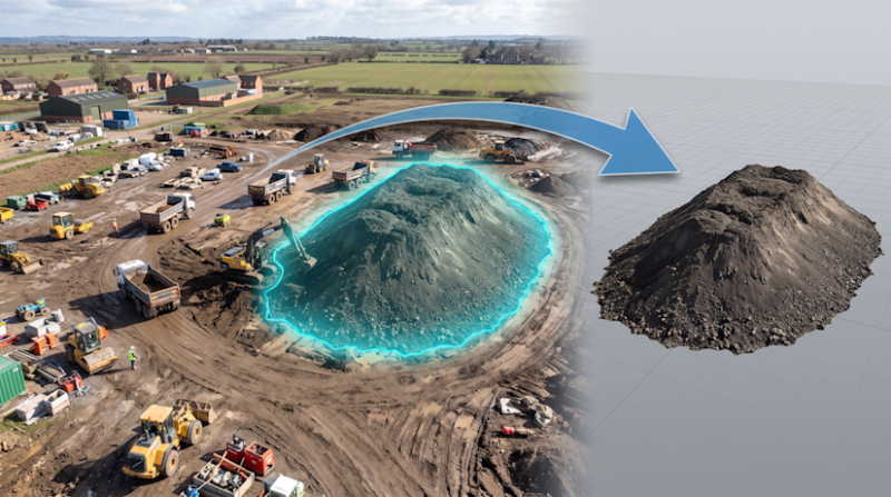
In Teesside we have been tracking earthworks and stockpile volumes on a live site
In Morecambe we traced an underperforming rooftop solar array back to its faulty strings.
Stockpiles & Earthworks Monitoring
The Teesside project team need regular, auditable cut and fill quantities and stockpile volumes for valuations and reconciliation. Walking piles with a GNSS rover takes hours, puts people on unstable material, takes surveyors and engineers away from more important tasks, and samples only a scatter of points.
Stockpiles captured from 3D terrain model
We fly a repeatable survey plan with RTK positioning tied to ground control, processing each flight into a georeferenced surface model. Industry evidence consistently puts volumetric accuracy for this method within 1-3%, comparable to a well run GNSS rover survey, with vertical surface accuracy around 3-5cm. Capture takes minutes per visit, and nobody sets foot on a pile.
Thermal Imaging for Solar O&M
In Morecambe, a commercial rooftop array was generating less than expected, but ground level electrical checks had not located the fault, and a conventional roof inspection would have meant scaffold or access equipment and working at height.
None functioning string identified, much wamer temperatures compared to the adjacent string
We flew a radiometric thermal camera over the array in line with IEC 62446-3, the international standard for thermographic PV inspection, in suitable irradiance. Electrical faults show as clear temperature patterns: a string running oddly cool suggests a disconnect or blown fuse, while a module with one warm third is the classic signature of a failed bypass diode.
So What?
A survey is only as useful as the deliverable it produces. A volume you can defend in a valuation meeting, or an anomaly map a contractor can act on the same day, is worth far more than a folder of aerial photographs.
Join us for an inspiring Chamber on Tour - Behind the scenes visit to Secret Garden Glamping - one of the UK and Ireland’s most talked-about luxury glamping bra...
Better Networking Accrington – Fortnightly Breakfast MeetingsJoin us in the heart of Accrington for our fortnightly Better Networking breakfast meetings – where...
If you’re considering adoption and would like to find out more about adopting a baby or toddler, we’d love to welcome you to our free information event.Join us...
The Big Sleepout is back in November 2026 - and we are looking to work with local business people as we need Event Sponsors to support our fundraising efforts.A...
How to Turn Organic Traffic into Measurable Revenue Search engine optimisation isn’t about vanity metrics. It’s about visibility, authority, and ultimately – gr...
Together with our partners, Code Galaxy, the Chamber is thrilled to announce an exciting, exclusive new Chamber network, designed to connect, inspire and champi...
 DroneWorks