Quoting a commercial rooftop solar installation usually starts with a problem: nobody has an accurate picture of the roof. Installers and PPA developers assessing large industrial or commercial buildings often rely on outdated site plans or satellite imagery that misses vents, skylights and other obstructions - detail that only shows up once someone actually gets on the roof.
DroneWorks provide a faster, safer way to capture that detail for a large commercial building being assessed for rooftop solar.
Large industrial roofs are difficult and expensive to access. Scaffolding, cherry pickers or rope access all add cost and time to a project that hasn't even been confirmed yet, and even then physical access rarely gives full coverage of a large roof.
Without accurate measurements and a clear roof profile, installers are left designing around assumptions - guessing at sheet profile, panel layout and obstruction clearances - which risks costly redesigns or delays once the project reaches installation.
DroneWorks survey commercial buildings using the DJI M350 with a 45-megapixel P1 sensor, capturing high-resolution overlapping imagery of the full roof in a single site visit alongside ground control points to tie the survey into an accurate coordinate system.
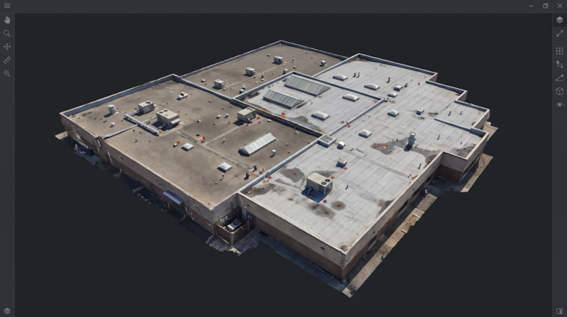
The imagery is processed into an orthophoto-backed 3D model, from which a CAD roof plan are extracted showing sheet profile, ridge and valley lines, and every visible obstruction - vents, skylights, plant and other protrusions - that would affect panel layou, all accurately positioned ready for the design team.
From one site visit, the project ended up with a full set of design-ready deliverables: CAD drawings, an orthophoto-backed roof plan, a 3D model for design and installation teams to explore before arriving on site, and high-resolution imagery to support an optional condition assessment - all without anyone needing to physically access the roof.
For installers and PPA developers working on similarly large or difficult-to-access buildings, that combination matters more than it might first appear.
A roof plan tied to real imagery is easier to trust and easier to review than hand-measured notes, and a shared 3D model means design, engineering and site teams can all work from the same understanding of the building without each arranging their own visit.
Then there’s the surveyors condition report….
Read the full article 👉
https://blog.drone-works.uk/post/drone-survey-3d-cad-commercial-rooftop-solar
 Brabners